Collaborative Navigation in Cities
Anat Schaper, M. Sc.
Erstbetreuer: S. Schön; Co-Betreuer:
In recent years, the demand for accurate and reliable positioning has increased. Especially with regard to autonomous driving, highly accurate positioning information is needed. While conventional Global Navigation Satellite System (GNSS) positioning solutions provide reliable results in open areas such as highways, this is quite different in urban environments (e.g. urban canyons, tunnels or underground car parks). Non-Line-of-Sight and multipath signals caused by surrounding buildings, trees or other interfering factors lead to large ranging errors. In tunnels or underground, satellite reception can even be completely disrupted. Positioning via pure GNSS solutions for autonomous driving is therefore absolutely unsuitable here. A one-metre error perpendicular to the direction of travel can have fatal consequences in road traffic. It is therefore obvious that position determination should not exclusively base on a GNSS solution.
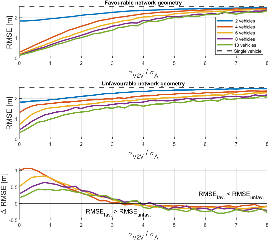
Multi-sensor-systems are frequently used to deal with the challenges that GNSS encounters in highly urbanised areas. By fusing all sensor information, the strengths of each sensor can be exploited, resulting in an improved and more robust position estimate. However, single-vehicle sensor fusion can also reach its limits, e.g. due to a limited perception range and field of view. Collaborative approaches address this problem by considering surrounding agents to support the ego-vehicle position: Various agents communicate with each other and exchange information using wireless communication technologies, or by performing measurements between each other. Vehicles that are in poor environments can thereby benefit from vehicles in more optimal conditions. Besides a possible positioning accuracy enhancement, communication between agents can additionally improve the traffic flow and contributes to a reduction in the risk of collision.
In this project, sensor fusion is applied to a multi-vehicle network in order to make statements about the opportunities and limitations of collaborative navigation on the accuracy and robustness of position determination: We aim to consider a multi-vehicle network, equipped with GNSS antennas and receivers, IMU’s, cameras and laser scanners. The core of the CP approach is Vehicle-to-Everything (V2X) communication, mainly in the form of Vehicle-to-Infrastructure (V2I) and Vehicle-to-Vehicle (V2V) communication, to support the GNSS (+ IMU) position solution and to achieve accurate and reliable position estimates of the vehicles. The derived CP algorithms are tested with real data recorded during an i.c.sens Mapathon. The positioning solution is compared with a reference trajectory in order to make statements about the accuracy and the reliability of the solution is investigated considering integrity criteria.
Schneiderberg 50
30167 Hannover


